A long list of historic and specialty Flatbush maps
If you like to geek out on maps, pour yourself a beverage and give yourself a solid 3 hours with this cartographic timeline of Flatbush history. I’ve also included some specialty maps that chart Flatbush’s topography, old train and trolley lines, historic district boundaries, building dates, population by racial identity, and more. Am I missing any? I’d love to hear about more maps you’ve found.
Historical Maps of Flatbush by Date
1766 map of the area, showing Flatbush Ave - It’s mostly forest and farmland, but you can see Flatbush Ave (originally a native trail) running straight through it. It’s labeled on this map as “The Road to Flatbush”
1798 map of Flatbush and the Flatlands - These maps are by Jeremiah Lott, a lifelong Flatbush resident. They show the borders of Flatbush and the Flatlands. Make sure to zoom in to see the corner of Flatbush and Church Aves.
1842 map of the town of Flatbush - Another map by Jeremiah Lott, this one is more detailed and shows where the Dutch farmers of old Flatbush lived. In 1843 it appeared in Reverend Strong’s History of Flatbush (a seminal work about the history of the village) and this reproduction of it is a more commonly seen version.
1855 map of the area surrounding Flatbush Ave - This hand-drawn map by famous Brooklynite (and former Erasmus student) TG Bergen is often available for viewing at the Brooklyn Historical Society library, and is rather breathtaking in person. (Just go into the library and ask about it!) Shows the site of the African Burial Ground on Church and Bedford.
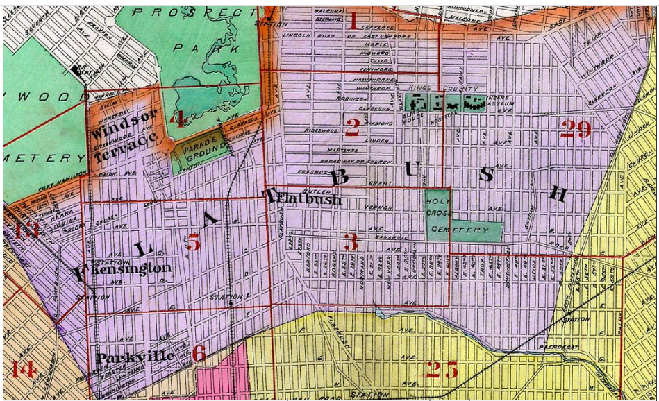
1859 map of East Flatbush - similar to the above map, but with detail on the area east of Flatbush Ave. Shows where the Asylum was.
1859 map of Kings and Queens Counties - This map is impressingly big. It shows how the different towns all fit together back then, who all the landowners were, and shows the “Friends Cemetery” before it was surrounded by Prospect Park.
1868 map of John Lefferts’ farm - This map was prepared before John Lefferts sold off his farm (the future Prospect Lefferts Gardens) and shows proposed street names (after presidents) that were never used
1869 Map of Kings County - Not yet part of Brooklyn, Flatbush encompasses Kensington and part of Windsor Terrace on this map, which also shows the stark contrast between how built-up Brooklyn (now downtown/Brooklyn Heights) was vs. the rest of Kings County
1870 Village of Flatbush Map - This fun map (made decades later) of the stores and landholders of Flatbush is probably the cutest map on this list. Here is a similar one for The Flatlands.
1873 Map with illustrations - Another decorative map created decades later, this map is notable for its drawings of old Dutch homesteads and also covers the area we now consider Windsor Terrace (maps of this time period were most likely made as decoration due to nostalgia for Dutch Flatbush, which disappeared around the 1890s).
1873 Flatbush town map - This map, which covers part of present-day Lefferts Gardens, East Flatbush, and what some people call Caton Park, denotes the original location of the Lefferts Historic House as “Res. John Lefferts.” You won’t recognize many street names beyond Ocean, Winthrop, Linden, and a few others. Working north to south (download the map to rotate it the proper direction), the old-to-new street name conversions are: East New York is Lincoln, Franklin is Parkside, Diamond is Lenox, East Broadway is Church, Waverly / Vernon is Tilden, and Road to Canarsie is Cortelyou.
Another 1873 map - This map shows the area we now often think of as “Ditmas Park” and includes the names of landowners
1880 - Brooklyn and vicinity - a corner of Flatbush appears at the bottom of this map
1890 Atlas of Kings County - these colorful maps have lots of juicy detail of Kensington, Ditmas Park, Prospect Lefferts Gardens, East Flatbush, etc. Unlike other maps on this list, this site is equipped with a sweet-ass zoom. Look at the second image to find the “plate number” of the area you’re looking for.
1898 Atlas of Brooklyn - This atlas is dense and detailed so keep an eye out for the numbers in circles at the edges of the map that tell you what plate number in the original atlas to go to find the next map over. Here are some jumping off points for yah:
Flatbush/Ditmas Park Area south of Prospect Park - The Parade Grounds are here, but the Prospect Park South Historic District is still owned by the Dutch Reformed Church.
Victorian Flatbush before the fancy street names - Cortelyou Road as Ave C and more old-school street names
East Flatbush and part of Midwood - but they’re not called that. A good map that shows where the area known as “Vanderveer Park” used to be
1906 Atlas of Brooklyn - In this atlas, Victorian Flatbush pops up overnight, and SWARM (Stratford, Westminster, Argyle, Rugby, Marlborough) appear with their old names in parentheses
1910 map of Brooklyn - In this street map, SWARM (Stratford, Westminster, Argyle, Rugby, Marlborough) has taken root in Victorian Flatbush
1917 Rand McNally map of Brooklyn - Here, 21st Street (between the future sites of Prospect Park and Parkside Q stations) is still intact. This map also notates where Vanderveer Park was
1920s map of Brooklyn - This map of all of Brooklyn has a good view of train lines
1931 map of Brooklyn - A straight-forward black-and-white map from Rand McNally
1950s map of Brooklyn - When Brooklyn neighborhoods were giant. Upside-down but all good once you download!
1962 map of 12th Congressional District - Basic black-and-white map of present-day Flatbush, Prospect Lefferts Gardens, and Kensington
1964 map of New York City - This map shows the area we think of as Ditmas Park as “Kensington.” Brooklyn College is present, and Pendergaat Basin is still there.
1970 map of the NYC area - This page from the National Atlas of the United States of America doesn’t show much detail (in fact, the entire NYC Metropolitan area shares a page with Washington, DC). But I find it notable because, even in an Atlas of the entire United States, it very clearly shows Flatbush Ave (just like the map from 1766 does)
Current map - Google says these are the current borders of Flatbush
Specialty Maps
Topographical Maps
US Geological Survey Maps - These interactive maps allow you to see topographical maps from 1889–1900 overlayed on a current map. Just zoom in and click anywhere.
Brooklyn Elevation Map (1889) - A jpg version of the 1889 US Geological Survey map. Check out how all the squiggly lines that indicate a new plateau suddenly disappear when you get to flat Flatbush
Terminal Moraine and Outwash Plain - This geological map of New York (including Flatbush) shows the types of soil left behind by the glacier that formed our topography
Transportation Maps
1910 Subway Map - Notice how the future Q line connects at Franklin Ave instead of going under the park, then goes over the Brooklyn Bridge!
1919 transportation map: “How to Reach Ebbets Field” - Who needs north to be “up” when you’re headed to the ballpark?
1930s trolley Lines for Brooklyn - basically, our future bus lines
1950 trolley and train lines - it’s hard not to love a hand-drawn map. This one is particularly notable for its tables on the bottom that give dates (prior to 1946) that lines were suspended (including Cortelyou Rd’s trolley on “7/23/30").
1967 subway map - Flatbush’s subway lines looking pretty familiar here
Real Estate Maps
Brooklyn buildings by decade - this incredible map created in 2013 traced the decade built for every building in the neighborhood and beyond
Flatbush property owners in 1790 - from the 1908 book Flatbush of Today
“Redlined” Flatbush Map (Interactive | Download ) - circa 1935-1940. During the New Deal, banks paid people to go to areas and assess how credit-worthy areas were--basically they went and counted the non-white people. These racist maps with long-lasting implications are an interesting look at what Flatbush looked like at the time, though. (Flatbush was rated a “B” by the way--”Still Desirable”! While East Flatbush got a “C,” which was for “Definitely Declining.”)
1940s rents in Brooklyn - Compiled by Con Ed, this map shows the average monthly rent by block. Although the dollar amount has gone way up (the highest shown here is $100/month), the block-by-block of which areas are more expensive than others hasn’t changed much.
Neighborhood Maps
Little Caribbean - Map, with highlights, of the Little Caribbean district in Flatbush
Little Haiti - Map of the Little Haiti District in Flatbush
Present day map of Victorian Flatbush neighborhoods - by Mary Kay Gallagher real estate - It’s not all Ditmas Park! This helpful map shows all the different Flatbush subdivisions (more for realty purposes rather than a historically accurate map of where the historic districts are).
Historic towns of Brooklyn - This map from 1944 is more cute than practical, but it shows the borders of the old Brooklyn towns (five Dutch, one English) and has drawings of some historic Flatbush buildings and homesteads
Official NYC Historic District Maps
Interactive NYC Landmarks and Historic District Map - Navigate over to Flatbush on this interactive map to see all of our Official NYC Landmarks and Historic Districts in one place.
PDF Maps - These individual maps show each landmarked historic district (including official boundaries) in Flatbush and Prospect Lefferts Gardens (Note: for Historic Designation Reports for these areas see the Books, Etc. section! For a list of all the historic districts in Brooklyn see this list.)
Albemarle Kenmore Terrace | Chester Court Historic District | Ditmas Park Historic District | Fiske Terrace-Midwood Park Historic District | Prospect Lefferts Gardens Historic District | Prospect Park South Historic District | Ocean on the Park Historic District
Other Speciality Maps
A retrospective of Flatbush maps by the Brooklyn Historic Society - The Brooklyn Historical Society looks at some historical Flatbush maps through the lens of the Lefferts family papers, explaining how it went from farmland to suburbs
Revolutionary War Map - This map shows how Flatbush was smack dab in the middle of the Battle of Brooklyn (aka the Battle of Long Island)
Battle of Long Island Map - Yep, that’s how they got us! This map from the University of Texas’ Perry-Casteñeda Collection shows the lines of attack from the British that forced American troops and elsewhere in present-day Brooklyn to retreat
1940s NYC Tax Photo map - This map by Julian Boilen takes photos of Flatbush from the 1940s (and blurry ones from the 80s) that were produced by the NYC government for tax purposes and super imposes them over a map. Like Google street view, but if you were in a time machine to the 1940s.
Racial Demographics of New York (2015) - This interactive map shows the racial demographics of our neighborhood based on the very broad racial and ethnic identities offered by the US Census
Street Trees of Flatbush - Interactive map from the NYC Parks Dept indicating the species, trunk diameter, and other information of every street tree in Flatbush and the surrounding neighborhoods.
Other Research Materials
Resources Home > Websites | Photos | Maps | Audio & Video | Books, Newspapers & Other Docs